

The Best Wrong Turn I Have Ever Made
State 13: North Dakota - August 25, 2017
“There are no wrong turns, only unexpected paths”
Mark Nepo
Nate
We woke up at a hotel in Williston, ND, and had an awful night sleep due to an extremely lumpy bed. After leaving the hotel, we headed across town to the Cross Country Couple's chosen “Historic Site” for North Dakota: The site of Sitting Bull's surrender. The decommissioned Army Post of Fort Buford was the actual site of the surrender, which officially ended armed hostilities between the US and Native Americans.
Between 1862-1881, Sitting Bull spearheaded a resistance movement towards the US government for policies against the Native Americans. Sitting Bull established his reputation as a leader from an early age, and inspired and unified other Indian tribes. US policies and treaties stole the land from the Indians and forced them to stay within the confines of their reservation. The Native Americans had lived on North America land for centuries, and Sitting Bull believed the US government did not possess the authority to say where his people lived. He refused to stay on the reservations, and he and his followers launched Guerilla attacks against the US Military to halt further encroachment on Native American land. By early 1876, Sitting Bull's camp grew to 10,000 people, and 2000 of which were Indian warriors. On June 7, 1876, Custer's 7th Calvary attacked Sitting Bull's camp. In the ensuing battle, The Native Americans decimated Custer's regiment in what has come to be known as “Custer's Last Stand”. To escape US retaliation, Sitting Bull and his followers escaped into Canada, where they lived in exile for the next 5 years. When food became scarce and starvation became inevitable, Sitting Bull and his remaining 186 followers returned to the US, and laid down their arms at Fort Buford on July 19, 1881. Upon surrendering his rifle, Sitting Bull said "I wish it to be remembered that I was the last man of my tribe to surrender my rifle. With that statement the US and Native American armed hostilities came to an end.
Fort Buford was established as a US Army Post on June 15, 1866, and decommissioned on October 1, 1895. Although the fort once consisted of 640 acres, only 40 acres remain under the control of the North Dakota Historical Society. After decommission, all structures within the fort were sold or torn down except for two. The 1872 Commanding Officer's Quarters, which is the exact building where Sitting Bull surrendered, and the 1875 Stone Powder Magazine which housed munitions.
IMG_7256 IMG_7230 IMG_7228
We began our visit in the Commanding Officers Quarters with an excellent guided tour. The displays provided an accurate picture of 19th century fort life. However, the highlight of our visit was standing in the exact room where Sitting Bull surrendered, which is pictured below.
IMG_7233 IMG_7225 IMG_7223 IMG_7224 IMG_7227
In 2004, a reproduction of the enlisted men’s barrack’s was constructed at the original site. This is where the infantry men lived, and includes the living quarters, the mess hall and the kitchen.
IMG_7255 IMG_7239 IMG_7243 IMG_7245 IMG_7248 IMG_7253
The building is still used regularly by historical re-enactors. All of the furnishings are of course reproductions, with a few exceptions. The metal stoves, the steel plate used for target practices, and the largest metal meat chopper I have ever seen in my entire life are all original.
IMG_7244 IMG_7246 IMG_7251
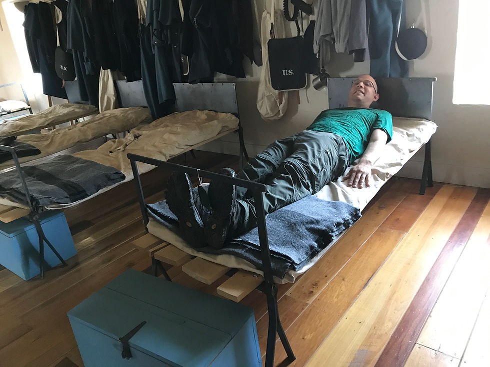
I had to seize the opportunity the lay on a reproduction 19th century US military issued straw mattress, because when would I ever have another opportunity to do so? Surprisingly, it was more comfy than the hotel mattress I slept on the night prior. With a straw mattress, you don’t have to worry about bed bugs; just hungry horses. I suggested to Lori we start sleeping on a straw mattress inside Rosie, but she said “Hay, I want no part of that”.
After departing Williston, ND, we headed south to the National Park depicted on the reverse of the North Dakota quarter: Theodore Roosevelt National Park. Named after our 26th President. Theodore Roosevelt National Park consists of 70,446 acres of badlands in Western North Dakota, and it was a 100-mile drive from Williston, ND to the entrance of the park. About 20 miles into our drive, Michelle, our GPS, and Lori told me to take a right turn. However, I was so busy singing along with the country songs on the radio, I took a left instead for some unknown reason. The GPS sarcastically yelled, and displayed on the screen in large bold letters “RECALCULATING!”, and Lori followed up with a “What the hell!” Now, you have to understand something. Rosie is 20 feet long, the roads are very narrow single lanes with no shoulder, and everything is extremely far apart in North Dakota. It’s not like you can just pull into a 7-11 and do a U turn. Missing a turn means a double digit mileage detour, gallons of wasted gas, and worst of all facing the full fury of my wife’s scorn. None of which are particularly enjoyable! I began looking for a place to turn around, and came across the sign pictured below.

Now we were very confused. Theodore Roosevelt National Park was 80 miles south of our current location. Unless we inadvertently drove Rosie through a rift in the time space continuum, there was no way we already arrived at the park. After parking Rosie, Lori went into the visitor center to speak with a ranger, who was just about to leave for the day. As it turns out, there are actually 3 entrances to the Theodore Roosevelt National Park: The North Entrance, the South Entrance, and the Elkhorn Ranch Unit. We were currently at the North Entrance, and the other 2 entrances were 80 miles south. Wow, what great luck! We didn’t even know this access point of the park even existed, and if I didn’t make a wrong turn, we would have entirely missed it! "AH HAH"! I demanded an apology from Lori and Michelle, but Lori just rolled her eyes, and Michelle conveniently powered down. Huh! Women!
The North Unit of the park consisted of a 14 mile out and back paved road. There were three lookout points along the path offering unprecedented views of the badlands, which are pictured below.
1st Edge of a Glacier Overlook
IMG_7121 IMG_7118 IMG_7119 IMG_7116 IMG_7117 IMG_7113
2nd Riverbend Overlook
IMG_7161 IMG_7087 IMG_7085 IMG_7083 IMG_7077 IMG_7082
3rd Oxbow Overlook
IMG_7130 IMG_7132 IMG_7135 IMG_7134 IMG_7133 IMG_7136
In addition to the 3 overlooks, we saw a doe and her fawn, an eagle in flight, pheasants in the prairie, and a herd of roaming bison: one of which came within 6 feet of Rosie. Bison are the largest land mammals in North America, and are gentle and graceful creatures. Our interaction with the bison of the Badlands will forever be one of the most memorable experiences of our cross country trip. Please view the pictures below.
IMG_7203 IMG_7002 IMG_7104 IMG_7208 IMG_7202 IMG_7199 IMG_6971 IMG_7003 IMG_7018 IMG_7150 IMG_7065 IMG_7156
Upon departing the North Unit of the park, we continued 80 miles south towards the south unit of Theodore Roosevelt National Park. Since we were quickly running out of daylight, we made the difficult decision not to visit the Elkhorn Ranch Unit of the park, and to instead continue on to the south unit. The South Unit of the park is the largest and most popular, and would be the perfect place to end the day. The entrance to the South Unit is in the town of Medora, ND. The town is a gigantic tourist trap masquerading as an old western town. However, we successfully navigated through the commercialism unscathed, and found the entrance of the park. Pictured below.
IMG_7351 IMG_7354 IMG_7352
The South Unit of Theodore Roosevelt National Park consists of a 36 mile lasso or lollipop shaped paved road, which returns back to the point of entrance. The three overlooks are pictured below
Prairie Dog Land Overlook
IMG_7272 IMG_7276 IMG_7274 IMG_7268 IMG_7282 IMG_7281 IMG_7269 IMG_7273
Badlands Overlook
IMG_7286 IMG_7292 IMG_7295 IMG_7293 IMG_7294 IMG_7291
River Woodland Overlook
IMG_7322 IMG_7335 IMG_7334 IMG_7324 IMG_7325 IMG_7327
In addition to the above, we saw wild feral horses and herds of roaming buffalo. One of the buffalo came right off the head of a hiking trail, and into the parking lot. He was using the trail marker as a scratching post. lol! Please see the pictures below.
IMG_7311 IMG_7309 IMG_7264 IMG_7296 IMG_7315 IMG_7317 IMG_7316 IMG_7318 IMG_7261 IMG_7263 IMG_7259 IMG_7319
Our overall experience of Badlands of Theodore Roosevelt National Park was extremely enjoyable. Albeit shorter and less frequented, the North Unit was much more beautiful and presented more opportunities for animal encounters than the South Unit of the park. I am very glad I made that wrong turn!
Upon exiting the south unit of the park, we noticed a primitive cabin behind the park's visitor center, and decide to investigate further. The structure is called the Maltese Cross Cabin, was once owned by President Theodore Roosevelt, and designated as a historic landmark. After his wife and mother died within hours of each other in 1884, Roosevelt became depressed, and retreated to this very cabin to mourn and to heal. Some personal effects of Theodore Roosevelt remain on display in the cabin, which include: the rocking chair, white hutch & writing desk, and Roosevelt's traveling trunk inscribed with his initials. Unfortunately, the visitors center was closed, and the cabin was locked. It would have been great to go inside. On a side note, there were numerous personal engravings from visitors carved in the external wood work of the cabin, which was very disheartening to witness. We wish people had more respect for our countries heritage, so future generations may enjoy what we have the privilege of enjoying today! Please see the pictures below.
IMG_7346 IMG_7349 IMG_7348
After departing the park, we drove 2 hours south to Mandan, ND, and found a Walmart to sleep at for the night.
Comments